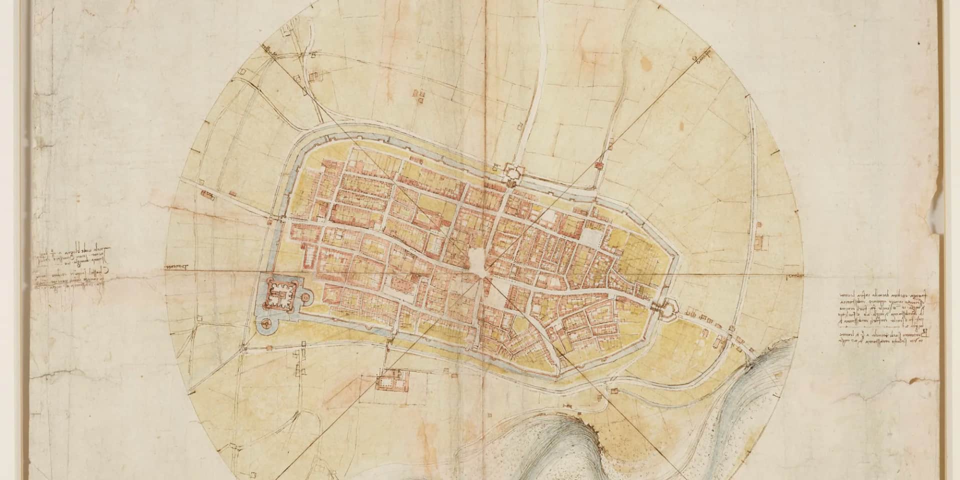
Look at it for two seconds and your brain says Google Maps. A walled town seen from directly above, its streets a pale web, its blocks shaded in pink, a fortress jutting from one corner and a river curling past below. Then you notice the handwriting around the edge is backwards, and the date is 1502.
The viral post says Leonardo da Vinci created the first ever "satellite view" map of Imola, Italy, and that he did it by measuring the angles and distance of every corner of every building in the city. The map is real and it's genuinely groundbreaking. But "first ever" goes too far, and the "every corner of every building" method isn't what the evidence shows.
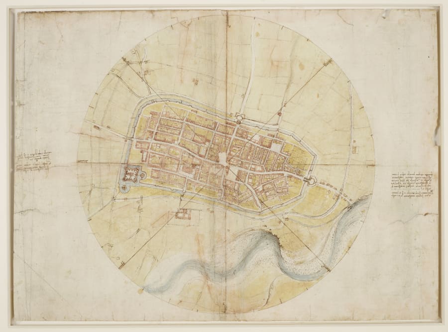
Why Leonardo was mapping Imola at all
In August 1502, the 50-year-old Leonardo was appointed military architect and engineer to Cesare Borgia, the ruthless son of Pope Alexander VI, who was carving out a state for himself in central Italy. Leonardo spent the following months touring Borgia's strongholds, inspecting fortresses and noting walls, ports and waterworks.
Imola, a small fortified town in Romagna, was one of them; Borgia's troops wintered there. A commander planning defenses needs to know exactly where the streets, walls and gates are. The map Leonardo produced is now in the Royal Collection in Britain, catalogued as RCIN 912284. It measures about 44 by 60 centimeters and is drawn in pen and ink with colored washes over black chalk, with lines incised by a stylus to set up its geometry.
What makes it look like a satellite image
Most city maps of the time were really pictures. They showed a town from a high, angled viewpoint, with churches and towers drawn as recognizable buildings and often enlarged for importance. Leonardo did something different. He drew Imola as a pure plan, as if from directly overhead: every block reduced to its footprint, nothing in perspective.
Cartographers call this an ichnographic plan, and it's the kind of map almost everyone uses today. National Geographic describes Leonardo's version as the first map to use measured data to show such a "flattened city," and notes that historians say it is accurate enough that you could still navigate Imola with it.
So "satellite view" is a fair way to describe how it looks. Of course, nobody was in the sky. Leonardo built the overhead view from measurements taken on the ground.
How he actually made it
This is where the viral version gets too precise. There's no evidence Leonardo measured the angles and distances of every corner of every building, and the map itself doesn't show individual buildings in that detail; it shows blocks.
What survives is revealing. A second sheet in the Royal Collection, RCIN 912686, contains Leonardo's rough sketches of Imola's street plan, broken into sections, with measurements written along the streets. That points to a method of measuring street lengths between intersections, then assembling the pieces.
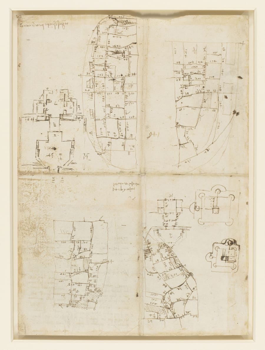
The finished map's circle is divided into the eight principal wind directions, radiating from a central point near the town square. Historians believe he worked out directions with a magnetic compass and measured distances on foot or with an odometer, a device he designed in several versions to count distance traveled. Exactly which instruments he used at Imola, and in what order, isn't recorded. Researchers still debate the details.
Leonardo's measurements still hold up.
— National Geographic, on the Imola plan
Was it really the first?
Not quite, and Leonardo himself was building on someone else's idea. Around the middle of the 15th century, the Florentine architect and scholar Leon Battista Alberti described a way to map Rome using what we'd now call polar coordinates: fix a central point, divide a circle around it into degrees, and record each landmark by its direction and distance. Leonardo's wind-circle at Imola follows the same logic, and National Geographic says he adapted Alberti's technique to capture distances and proportions more accurately.
There's also a long-running debate about whether Leonardo started from scratch. Imola had been surveyed before: a Sforza engineer, Danesio Maineri, worked on the town's fortress and walls in the early 1470s. The art historian Daniel Arasse argued that Leonardo adapted an existing plan by Maineri, partly because the town on the map seems to reflect Imola as it was decades earlier. Others note there's no proof Maineri ever mapped the interior streets, and Leonardo's own measured sketches show he did real fieldwork. The fairest summary is that Leonardo did survey Imola himself but may have checked his work against older records.
What the evidence does support is narrower, and still impressive: the Imola plan is generally regarded as the earliest surviving example of an accurately measured overhead town plan. Personally, I think that's the more interesting claim. Leonardo didn't invent mapping from nothing. He took a mathematical idea that had existed on paper and turned it into a working map so precise that it looks modern 500 years later.
The viral claim
Leonardo created the first ever 'satellite view' map in 1502 by measuring the angles and distance of every corner of every building in Imola.
What the evidence shows
The 1502 plan is real and is often called the earliest surviving accurate overhead town plan. It built on Alberti's earlier method, and Leonardo measured streets and directions, not every building corner.
How the Imola plan came about
- Mid-1400sLeon Battista Alberti describes mapping Rome with directions and distances measured from a central point.
- Early 1470sEngineer Danesio Maineri works on Imola's fortress and walls.
- Aug 1502Leonardo is appointed military architect and engineer to Cesare Borgia.
- Late 1502Leonardo surveys Imola and draws his overhead plan, now RCIN 912284.
- TodayThe plan is in the Royal Collection in Britain, alongside his measured street sketches (RCIN 912686).
The bottom line
- Leonardo really did draw an overhead map of Imola in 1502, while working as Cesare Borgia's military engineer.
- It's often described as the earliest surviving accurately measured overhead (ichnographic) town plan.
- It wasn't conceptually first: it adapted Leon Battista Alberti's earlier method of mapping from a central point.
- He measured streets and directions on the ground; there's no evidence he measured every corner of every building.
- The exact instruments and steps he used aren't documented, and scholars still debate whether he used an older plan.
Read next: The 'mushroom' in Eden: what a medieval fresco really shows · The Roman writer who described germs in 37 BC · Ea-nasir and the world's oldest customer complaint
Sources
- Royal Collection Trust, Leonardo da Vinci, A map of Imola (RCIN 912284) and Sketches of the street plan of Imola (RCIN 912686).
- Royal Collection Trust, "Mapmaker and engineer," Leonardo da Vinci: A Life in Drawing.
- Google Arts & Culture, Plan of Imola, Royal Collection Trust (medium, dimensions, provenance).
- National Geographic, "Leonardo da Vinci's Imola Plan changed mapping from art to science" (2020).
- Fumey G. "Léonard de Vinci, cartographe-dessinateur." La Géographie (2019), summarizing Daniel Arasse's view on the Maineri plan.
- Blevins R. "Leonardo da Vinci, Land Surveyor and Cartographer." FIG Congress (2010).
- Vox, "How Leonardo da Vinci made a 'satellite' map in 1502" (2019).
- Images: Royal Collection Trust RCIN 912284 and RCIN 912686, public domain, via Wikimedia Commons.